Civic Precinct in Vereeniging CBD
Diagram - Concept design for Vereeniging CBD
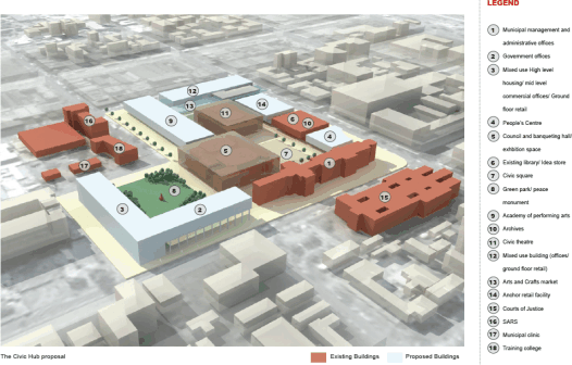
The Objectives of the Civic Precinct are clear. The core of the project rests the creation of:
- a civic hub.
- a heart for Vereeniging.
- a place for people with a focus on cultural and commercial activities.
The Precinct is to accommodate Muncipality administration offices. Public services and Community amenities will be enhanced and continued to be offered at a subsidised rate. The Precinct is further a mixed use development with a potential for housing, enriching levels of use by people over a greater time period.
In the short term, the Precinct needs to be a temporary 2010 World Cup viewing and event facility.
Delivery of the Precinct, is envisaged to be developed in partnership with the private sector (RFI) and the revenue streams from the commercial programme cross-subsidising the public amenities. The site proposal includes the neighbouring ABSA owned land, and further if it would appear economically advantageous and available, development opportunities related to neighbouring land north-west of the Civic hub (SARS and others) could be considered within the development framework.
The final key objective, relates to sustainability of the development of the Precinct. It is to be economically, socially and culturally sustainable for both current and future generations. In order to fulfil this aspiration a number of key essential components have been identified, such as ease of access for the general public and a number of desirable components that would add to the success of the Precinct.
The Heritage Precinct
The Heritage Precinct (Memorial site, police station, community hall, library, museum, and groups of houses and shops) together with the stadium and environs on the one side and the church precinct with its linkage to the Heritage site on the other in combination with Seiso Street, the main arterial road linking the township with the CBD, and the Dam with its coastline and linkages to the Heritage complex, provides for an enormous amount of development and regeneration opportunities.
The alignment of Seiso Street through the centre of the greater part of the township makes it extremely accessible and convenient for a majority of the residents to commercial and other services that are necessary and desirable in the township.
Dabula Drive which is the main vehicular linkage between the Heritage Site and the R42 Provincial Road, being the main road linking Vereeniging to Vanderbijlpark, is also well positioned in relation to the remaining residents of Sharpeville and should be included in a regeneration programme.
The edge of the Dhlomo Dam offers a plethora of opportunities but as with the Heritage Site all stakeholders need to participate in the formulation of plans.
Diagram - Concept design for Heritage Precinct in Sharpeville
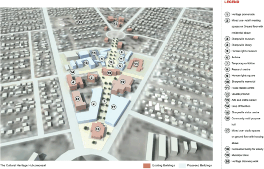
In order to celebrate and commemorate the international significance of Sharpeville as a Human Rights Heritage site, provide opportunities to develop and strengthen sustainable communities and attract private investment into the Sharpeville area, the following interrelated precincts were established:
- A Precinct with a heritage focus i.e. the Heritage Hub.
- A Precinct with a sports focus, i.e. the Integrated and Sustainable Sports Hub.
- A Precinct with a recreational focus i.e. Dhlomo Dam - a Gateway to Sharpeville.
There is already a commitment in place from the Road and Public Works Department and the National Treasury to provide public funds to support the initiative.
The Heritage Hub
The Heritage Hub needs to fulfil a number of objectives:
- Performing as a Community Hub.
- Being a Catalyst for urban regeneration and economic development.
- Integrating and unifying the existing heritage, cultural, community and religious functions on site.
Further, it needs to encourage sustainable tourism, enable job creation including opportunities for emerging entrepreneurs, promote local arts and crafts and provide a new approach to integrated and sustainable housing.
It is envisaged that a project management team will draw in and coordinate the central Public Funds and encourage small entrepreneurs to be engaged in the
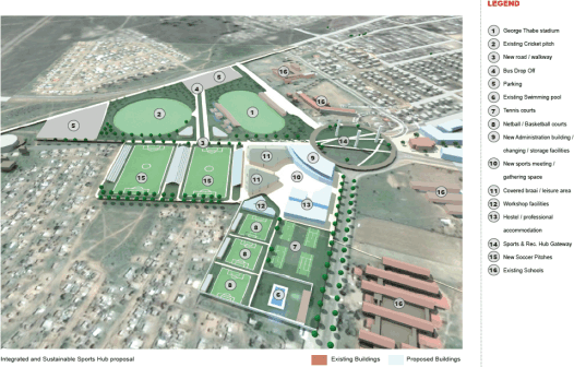
The Sports Hub
The Sports hub is to develop into a long term sustainable professional sports league base with surrounding facilities for general public participation.
To obtain this objective the Precinct needs to:
- Upgrade George Thabe Stadium and environs to ensure that facilities can be used for PSL and Mvela League Games.
- Upgrade the existing Cricket Ground and environs to cater for professional games.
- Provide high quality facilities for mass participation in sport.
It is envisaged that this development will be funded by a combination of public and private investment in collaboration with a professional Sports Club.
Diagram - Concept design for integrated and sustainable Sports Hub
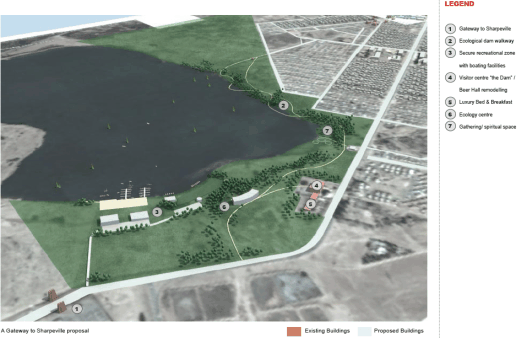
Dhlomo Dam: A gateway to Sharpeville
The key focus of this Precinct is the reinstatement and renewal of the Dhlomo Dam into a dignified recreational hub for the people, set in a desirable natural environment. A considered and sustainable intervention is required in an environmentally sensitive area in order to provide maximum benefit for the public.
This initiative is to enable urban regeneration and promote social responsibility. It is to be part of a long term approach in which further exploitation opportunities of the Dam will be explored.
This precinct will be driven and funded primarily from public funds including the Neighbourhood Partnership Fund. Where possible private sector, parastatal and NGO sponsorship will be sought.
Diagram - Concept design for the Gateway to Sharpeville
The Waterfront Precinct
The Vaal River coastline extending from the railway bridge at Dickenson Park to where the R59 freeway crosses the river to Sasolburg is a distance of 4 km.
Dickenson Park, being approximately 8ha in extent, enjoys a Vaal River frontage of some 400 – 500 metres and a width of some 250 metres at its widest. It is owned by the Emfuleni Local Municipality and has, for a great number of years, been developed and used for a variety of recreational activities. It is bounded by Mario Melani Road which is routed parallel to the river and from which it gains its access; the railway line from Vereeniging southwards across the river to Viljoensdrift in the Free State which defines its western or downstream boundary; the Vaal River and finally tapering off upstream towards the FW de Klerk road bridge.
Key to the success of development opportunities along the banks of the Vaal River is the adequate provision for public access to the river for leisure and recreation. Currently the ever-increasing private property development along the river is making it increasingly difficult to for local tourists and members of the public to gain access to the riverfront.
The stretch of Vaal River coastline extending from the railway bridge at Dickenson Park to where the R59 freeway crosses the river to Sasolburg, provides unique development opportunities for the area.
Except for some ½ km of coastline utilized by Rand Water, SAS Navy and the Riviera Aquatic Club the 4km stretch of Coastline is potentially available for development of a recreational nature.
Diagram - Concept design for Waterfront Precinct

In order to exploit the full potential of the Vaal river as a tourist destination, reposition the CBD towards the riverfront and unlock the Riverfront for economic development opportunities whilst safeguarding public access along the Vaal, an integrated regional vision is required for the Vaal Riverfront, which includes the following interrelated precincts:
- Dickenson Park Recreation Hub, adjacent to the railway bridge across the Vaal River.
- The Business Park, linking the CBD with the Vaal river.
- The Waterfront Promenade, covering the coastline between the CBD and the R59 freeway.
- The Water Tourism Hub, between Dickenson Park and the R59 freeway.
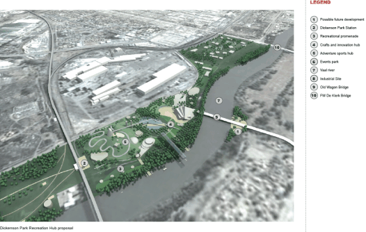
The Dickenson Park Recreation Hub
The Dickenson Park Recreation Hub is to be developed in 2 phases to fulfil a number of objectives:
- Creation of a recreational park which exploits the natural features and attraction of the Vaal River Waterfront.
- Development of a continuous, safe and secure, nature and recreation promenade “for the people” along the Dickenson Park/Vaal Riverfront.
- The Dickenson Park Recreation Hub will be developed in two phases:
- Phase 1 - completed by 2010: Upgrade of the current site into a recreational Park with integration of a multi purpose events/viewing site
and associated retail facilities. - Phase 2 - initiated after 2010: Transformation of the Dickenson Park site into a Recreation/ Crafts and Innovation park.
The Dickenson Park upgrade (Phase 1) is a 2010 Project which will be public sector driven. The 2nd phase of the development will require private sector investment.
Diagram - Concept design for Dickenson Park Recreation Hub
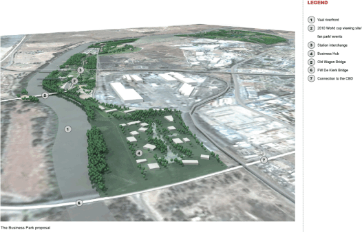
The Business Park
The Business Park Precinct is to fulfil the following objectives:
- To reposition the CBD towards the Waterfront by integrating the Business Park into the CBD Regeneration strategy.
- To increase the urban links between the CBD and the riverfront by improving the existing linkages across the rail infrastructure.
- Creating a desirable business location, close to the infrastructure and activities of the CBD, and exploit the need for local office space in order
to create opportunities for job creation, entrepreneurship and business tourism. - To reinforce the linkage of the CBD with the various destination points along the green Vaal River corridor.
- To demonstrate and pilot sustainable and environmentally friendly development.
This precinct will needed to be funded by the private sector with the public sector playing an enabling role.
Diagram - Concept design for Business Park
The Water Promenade
The Waterfront Promenade Precinct is to fulfil the following objectives:
- To bring the Vaal river front back to “the people”.
- To provide high quality recreation to all members of the public by providing access to the Riverfront, its facilities and river activities.
- Exploit the full potential of the Vaal river as a tourist destination.
- To enable controlled sustainable management of environmentally sensitive areas.
This Precinct proposal will be driven by the Public Sector. The procurement opportunities are to be explored in conjunction with the other Waterfront Precincts identified.
Diagram - Concept design for Northern Section of Waterfont Promenade

The Water Tourism Hub
The Water Tourism Hub is to fulfil the objectives listed below:
- Creation of a catalyst for urban regeneration and economic development along the Vaal river.
- Improvement of the accessibility to the Riverfront fom the North and West of Vereeniging in order to unlock the development opportunities
of a significant area of the Waterfront, adjacent to the R59 freeway. - Creation of a destination of high quality and national signifance which exploits and strengthens the tourism potential of the Vaal River.
- Enabling education, skills transfer and long term job creation.
This Precinct proposal will be initiated by the Public Sector and will required Private Sector collaboration. The procurement opportunities are to be explored in conjunction with the other Waterfront Precincts identified.
Diagram - Concept design for the Water Tourism Hub